
Dirt Bike Riding at Lake Tahoe
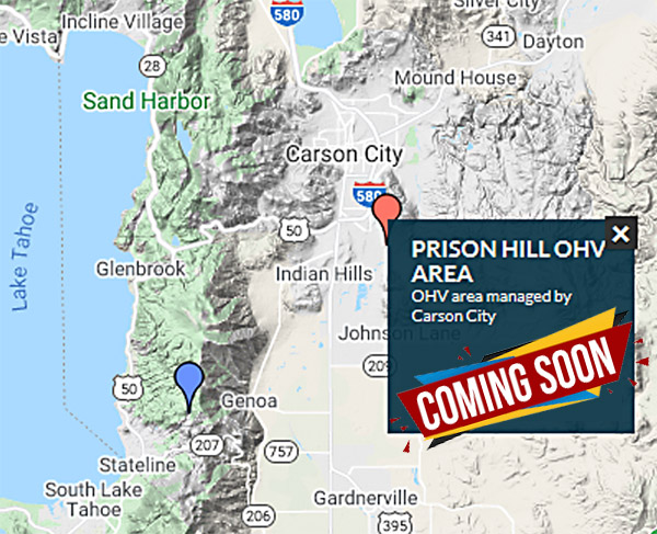
Dirt Bike Riding at Prison Hill OHV
(Requires javascript)
Dirt biking was our first sport! So let's go dirt riding at Lake Tahoe. The video above features Prison Hill OHV trails, just down the hill to the West of South Lake Tahoe in Carson City, Nevada where these riders found challenges, fun and an epic fail!
Lake Tahoe Dirt Riding and Off-Highway Vehicle Adventure Guides and Maps
When you go off road Tahoe, the California Off-Highway Motor Vehicle Division Off-Highway Adventure Guide is a great resource! It's a big fat file to download, but it's worth the wait. For this great list of OHV opportunities, go here: Off-Highway Vehicle Adventure guide [PDF 3.5 MB]

More Guides for Dirt Riding at Lake Tahoe
|
Super Awesome Map shows All Lake Tahoe ORV trails. You will have to zoom in quite a bit, to see the ORV icons for where you want to go. Nevertheless, this map is a great way to find places to ride! California State Vehicular Recreation Areas (SVRAs) Loads of Links to Tahoe OHV Areas by Bureau of Land Management Handy chart that tells where you can ride motorcycles. Scroll down to see it on page 3 of this publication by US Dept. of Agriculture |
Featured Dirt Riding Trails
Dirt Biking at Tahoe South East: Castle Rock/Genoa Peak Trailhead
 Located
East of South Lake Tahoe are the trails accessible from Castle Rock/Genoa Peak Trailhead. It's just off the hill, as the
locals say, and this trail is a really nice place for off road motorcycling
very near Lake Tahoe! We've been off road all around the Lake, and this trail
gets our thumbs up!
Located
East of South Lake Tahoe are the trails accessible from Castle Rock/Genoa Peak Trailhead. It's just off the hill, as the
locals say, and this trail is a really nice place for off road motorcycling
very near Lake Tahoe! We've been off road all around the Lake, and this trail
gets our thumbs up!
There's a little bit of name confusion when referencing the trailhead, because Google maps place Castle Rock Trailheads in several places, two of them being near Lake Tahoe. So, please be aware that we're talking about the trailhead that is pretty much directly West of Genoa, Nevada.
When you're not focusing on riding this mostly awesome double track, and whenever you take a moment to stop to gaze at the scenery, the trails here will treat you to fantastic scenic views. Even though this is also a popular area for mountain biking, hiking and trail running (and some of the trails do lead to private backyards, which means that you may have to backtrack and then explore elsewhere), this is a super fun trail system for dirt riding. You will enjoy lots of nice riding once you mount your steed and roll out of the trailhead parking lot. Even though you're sharing the trail, it's OHV OK, and trails are specifically marked for motorcycles.
You will find nearly 10 miles of double track dirt roads, tons of off-branching trails, and a few areas for doing donuts and general dirt bike playing.
For those wanting to go far, you can keep going North toward South Camp Peak, Duane Bliss Peak and finally Hwy 50 above Glenbrook, on the generally North-and-South running main trail road.
Get yourself a US Forest Service topo map set for Tahoe and you won't get lost.
For those wanting to stay out longer, there's also a little primitive camping in the area.
How to get to the Castle Rock Trailhead.
Start in Carson City, Nevada. Go South on Hwy 395 S. for 13 miles. At Hwy 88 turn South and go 2 miles. At State Route 207 Kingsbury Grade turn right. Now, you are going West. Continue on 207 for a little over 11 miles. When you see N. Benjamin Dr., turn right, and you will be going North. Go 1 1/2 miles and you will notice that N. Benjamin Drive turns into Andria Drive, and you are now on Andria Dr. This is a pretty drive in and of itself, since you are on a nice asphalt road winding its way up the side of the foothill, with upscale homes sparsely scattered around you. Look on your left, and you will see the place to park. It's called Castle Rock Trailhead. Now, it's time to explore and enjoy!
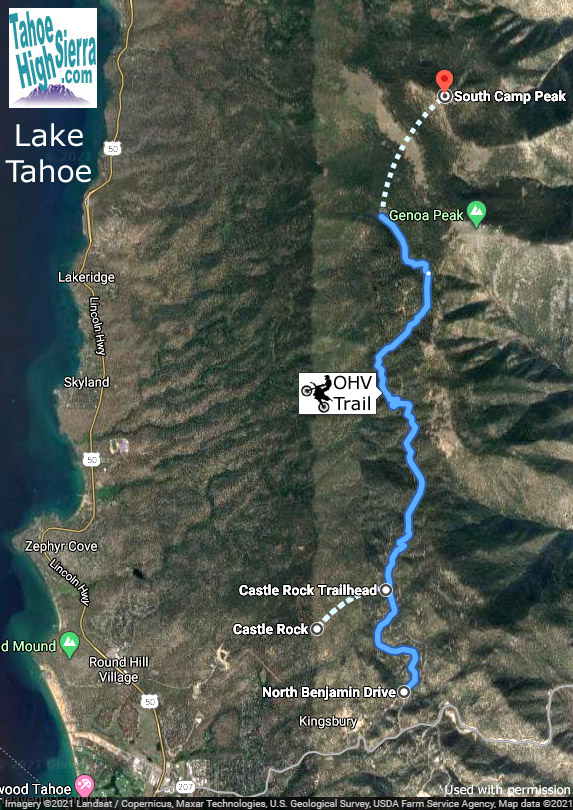
Castle Rock Trailhead Map
This Google map shows to road to the Castle Rock Trailhead and aerial view of the trail. You can also see Castle Rock as the crow flies to the West of the Castle Rock Trailhead. But, you won't be dirt biking all the way up to the top of Castle Rock, since it requires scrambling. If you want to see more trail details, or if you want to view the entire trail going North toward South Camp Peak, Duane Bliss Peak and finally Hwy 50 above Glenbrook, just click on the map to go to it on Google.
Want to double check our directions and get more information before you head out? Check out the State of Nevada ohv.nv.gov page for Genoa Peak and Indian Hills OHV area.
Visitors to our Tahoe Dirt Biking page really like this bike rack.

Rage Powersports Black Widow AMC-600-2 Aluminum Double Motorcycle Carrier

More Tahoe Area Dirt Bike Trails and Maps Are Coming Soon! We plan to feature Kingsbury Grade Trail, Dirt Biking Trails on Spooner Summit, Kingsbury Stinger Trail, and more off-the-hill dirt bike heaven like Prison Hill OHV Area. We've explored them all, and so can you.
We hope you have enjoyed our Lake Tahoe dirt biking ORV page. Please support our Lake Tahoe website by patronizong our sponsors when looking for Lake Tahoe maps, guides, lodging or other products. Thank you for visiting and enjoy your dirt bike riding at Lake Tahoe and Beyond!
-- Your Hosts,
Tom and Mary Kay